
A MW5.1 Earthquake Occurred at 9:09PM in La Habra on March 28th, 2014
CISN/SCSC Executive Summary (E. Hauksson, A. Guarino, K. Hutton, N. Scheckel – Caltech Seismological Laboratory; R. Graves, K. Hudnut, L. Jones, Karen Feltzer – USGS)
Version 4 – 10:42AM PDT 4/2/2014
LATEST UPDATE – WEDNESDAY APRIL 2, 10:45AM PDT
UPDATE – WEDNESDAY, APRIL 2, 2014 10:45AM
As of Wednesday, April 2, at 10:46AM, there have been 211 aftershocks ranging from M1.0-M4.1. The largest, a M4.1, occurred on Saturday afternoon at 2:32PM, and was felt widely throughout Southern California. The list below shows all 60 events M2 and larger that have occurred in the sequence:
| #EVID | MAG | YYYY/MM/DD HH:mm:SS | LAT | LON | DEP | LOCATION |
|---|---|---|---|---|---|---|
| 15481633 | 3.6 | 2014/03/28 20:03:39 | 33 55.5 N | 117 56.1 W | 7.5 | 2 km (1 mi) ESE of La Habra, CA |
| 15481657 | 2.1 | 2014/03/28 20:16:47 | 33 55.6 N | 117 55.1 W | 3.9 | 2 km (1 mi) NW of Brea, CA |
| 15481673 | 5.1 | 2014/03/28 21:09:42 | 33 55.1 N | 117 56.6 W | 7.5 | 2 km (1 mi) SSE of La Habra, CA |
| 15481681 | 3.2 | 2014/03/28 21:11:53 | 33 55.2 N | 117 55.9 W | 2.2 | 2 km (1 mi) ESE of La Habra, CA |
| 37183333 | 2.5 | 2014/03/28 21:12:18 | 33 57.3 N | 117 53.5 W | 1.8 | 4 km (3 mi) N of Brea, CA |
| 15481689 | 2.0 | 2014/03/28 21:13:54 | 33 55.5 N | 117 55.5 W | 3.3 | 3 km (2 mi) WNW of Brea, CA |
| 37183493 | 2.2 | 2014/03/28 21:15:18 | 33 54.4 N | 117 57.2 W | 2.3 | 3 km (2 mi) S of La Habra, CA |
| 15481721 | 2.0 | 2014/03/28 21:18:01 | 33 55.2 N | 117 55.8 W | 8.3 | 2 km (2 mi) ESE of La Habra, CA |
| 15481737 | 2.3 | 2014/03/28 21:19:54 | 33 54.8 N | 117 55.6 W | 3.5 | 3 km (2 mi) W of Brea, CA |
| 15481777 | 3.6 | 2014/03/28 21:30:51 | 33 55.0 N | 117 55.9 W | 4.1 | 3 km (2 mi) SE of La Habra, CA |
| 15481785 | 2.1 | 2014/03/28 21:32:13 | 33 54.8 N | 117 56.0 W | 3.6 | 3 km (2 mi) SE of La Habra, CA |
| 15481857 | 2.6 | 2014/03/28 21:45:37 | 33 56.3 N | 117 53.9 W | 1.4 | 2 km (1 mi) N of Brea, CA |
| 15481865 | 2.8 | 2014/03/28 21:47:12 | 33 55.5 N | 117 55.5 W | 4.0 | 2 km (2 mi) WNW of Brea, CA |
| 15481889 | 2.7 | 2014/03/28 21:53:57 | 33 56.4 N | 117 54.4 W | 2.6 | 3 km (2 mi) NNW of Brea, CA |
| 15481905 | 2.4 | 2014/03/28 21:56:45 | 33 55.4 N | 117 55.4 W | 0.5 | 2 km (1 mi) WNW of Brea, CA |
| 15481921 | 2.7 | 2014/03/28 22:05:31 | 33 56.1 N | 117 55.5 W | 0.7 | 3 km (2 mi) E of La Habra, CA |
| 15481913 | 2.6 | 2014/03/28 22:05:31 | 33 56.2 N | 117 54.5 W | 2.4 | 2 km (1 mi) NNW of Brea, CA |
| 15481969 | 3.1 | 2014/03/28 22:37:14 | 33 55.3 N | 117 54.0 W | 4.3 | 1 km (0 mi) N of Brea, CA |
| 15482025 | 2.3 | 2014/03/28 23:12:30 | 33 54.1 N | 117 57.3 W | 0.5 | 3 km (2 mi) S of La Habra, CA |
| 15482033 | 2.3 | 2014/03/28 23:12:45 | 33 54.3 N | 117 56.8 W | 0.1 | 3 km (2 mi) SSE of La Habra, CA |
| 15482073 | 2.1 | 2014/03/28 23:21:52 | 33 55.5 N | 117 55.4 W | 0.8 | 2 km (1 mi) WNW of Brea, CA |
| 15482121 | 2.3 | 2014/03/28 23:42:19 | 33 54.3 N | 117 56.3 W | 2.4 | 3 km (2 mi) SSE of La Habra, CA |
| 15482193 | 2.4 | 2014/03/29 00:17:27 | 33 55.5 N | 117 55.1 W | 1.3 | 2 km (1 mi) WNW of Brea, CA |
| 15482305 | 2.3 | 2014/03/29 01:26:41 | 33 54.6 N | 117 56.7 W | 2.0 | 3 km (2 mi) SSE of La Habra, CA |
| 15482417 | 2.6 | 2014/03/29 02:49:41 | 33 54.3 N | 117 57.3 W | 3.4 | 3 km (2 mi) S of La Habra, CA |
| 15482473 | 2.8 | 2014/03/29 03:31:51 | 33 54.7 N | 117 56.6 W | 0.9 | 2 km (2 mi) SSE of La Habra, CA |
| 15482617 | 2.5 | 2014/03/29 05:04:27 | 33 55.8 N | 117 55.1 W | 4.7 | 2 km (1 mi) NW of Brea, CA |
| 15482721 | 2.4 | 2014/03/29 07:48:13 | 33 53.9 N | 117 57.8 W | 3.9 | 4 km (2 mi) SSW of La Habra, CA |
| 15482745 | 2.3 | 2014/03/29 07:53:49 | 33 53.9 N | 117 57.0 W | 0.9 | 4 km (2 mi) S of La Habra, CA |
| 15482809 | 2.1 | 2014/03/29 08:58:02 | 33 54.3 N | 117 57.3 W | 0.4 | 3 km (2 mi) S of La Habra, CA |
| 15482817 | 3.4 | 2014/03/29 09:02:06 | 33 54.2 N | 117 57.3 W | 3.8 | 3 km (2 mi) S of La Habra, CA |
| 15482889 | 2.1 | 2014/03/29 10:41:18 | 33 54.2 N | 117 56.5 W | 2.7 | 3 km (2 mi) SSE of La Habra, CA |
| 15482913 | 2.1 | 2014/03/29 11:07:35 | 33 54.4 N | 117 56.6 W | 0.1 | 3 km (2 mi) SSE of La Habra, CA |
| 15483001 | 4.1 | 2014/03/29 14:32:45 | 33 57.7 N | 117 53.5 W | 9.4 | 5 km (3 mi) N of Brea, CA |
| 15483017 | 2.2 | 2014/03/29 14:36:12 | 33 57.4 N | 117 54.2 W | 5.0 | 4 km (3 mi) N of Brea, CA |
| 15483081 | 2.1 | 2014/03/29 16:00:19 | 33 57.7 N | 117 54.3 W | 1.7 | 5 km (3 mi) N of Brea, CA |
| 15483265 | 2.6 | 2014/03/29 20:48:20 | 33 54.7 N | 117 55.5 W | 1.7 | 2 km (1 mi) WSW of Brea, CA |
| 15483281 | 2.3 | 2014/03/29 21:10:11 | 33 54.1 N | 117 56.2 W | 1.0 | 4 km (2 mi) SSE of La Habra, CA |
| 15483305 | 2.4 | 2014/03/29 22:00:07 | 33 56.7 N | 117 54.4 W | 5.1 | 3 km (2 mi) N of Brea, CA |
| 15483313 | 2.5 | 2014/03/29 22:06:33 | 33 54.0 N | 117 57.3 W | 2.4 | 4 km (2 mi) S of La Habra, CA |
| 15483353 | 2.5 | 2014/03/29 22:23:00 | 33 56.3 N | 117 54.0 W | 1.6 | 2 km (1 mi) N of Brea, CA |
| 15483377 | 3.3 | 2014/03/29 22:51:22 | 33 54.2 N | 117 57.0 W | 1.8 | 3 km (2 mi) S of La Habra, CA |
| 15483393 | 3.1 | 2014/03/29 23:17:31 | 33 54.5 N | 117 56.9 W | 1.8 | 3 km (2 mi) SSE of La Habra, CA |
| 15483401 | 2.8 | 2014/03/29 23:31:50 | 33 54.6 N | 117 56.5 W | 1.5 | 3 km (2 mi) SSE of La Habra, CA |
| 15483441 | 2.5 | 2014/03/30 01:13:59 | 33 55.8 N | 117 54.9 W | 0.2 | 2 km (1 mi) NW of Brea, CA |
| 15483577 | 2.7 | 2014/03/30 09:05:00 | 33 54.9 N | 117 56.7 W | 0.4 | 2 km (1 mi) SSE of La Habra, CA |
| 15483737 | 2.0 | 2014/03/30 16:10:34 | 33 57.4 N | 117 53.3 W | 5.0 | 5 km (3 mi) NNE of Brea, CA |
| 15483761 | 2.3 | 2014/03/30 17:58:01 | 33 54.6 N | 117 57.3 W | 1.8 | 2 km (2 mi) S of La Habra, CA |
| 15483769 | 2.4 | 2014/03/30 17:59:50 | 33 54.0 N | 117 57.5 W | 0.6 | 4 km (2 mi) S of La Habra, CA |
| 15483977 | 2.1 | 2014/03/31 04:41:22 | 33 57.7 N | 117 54.1 W | 6.3 | 5 km (3 mi) N of Brea, CA |
| 15484049 | 2.0 | 2014/03/31 07:15:53 | 33 55.5 N | 117 54.7 W | 4.0 | 1 km (1 mi) NW of Brea, CA |
| 15484065 | 2.0 | 2014/03/31 07:21:17 | 33 55.0 N | 117 56.1 W | 1.7 | 2 km (1 mi) SE of La Habra, CA |
| 15484137 | 2.1 | 2014/03/31 11:14:23 | 33 55.2 N | 117 56.0 W | 3.2 | 2 km (1 mi) SE of La Habra, CA |
| 15484145 | 2.7 | 2014/03/31 11:17:28 | 33 55.0 N | 117 56.4 W | 3.6 | 2 km (1 mi) SE of La Habra, CA |
| 15484169 | 2.5 | 2014/03/31 12:14:06 | 33 55.1 N | 117 56.2 W | 4.2 | 2 km (1 mi) SE of La Habra, CA |
| 15484185 | 2.4 | 2014/03/31 14:31:13 | 33 53.8 N | 117 57.3 W | 4.0 | 4 km (2 mi) S of La Habra, CA |
| 15484417 | 2.8 | 2014/04/01 06:02:49 | 33 54.5 N | 117 57.2 W | 4.3 | 3 km (2 mi) S of La Habra, CA |
| 15484497 | 2.5 | 2014/04/01 11:29:44 | 33 54.5 N | 117 57.1 W | 3.8 | 3 km (2 mi) S of La Habra, CA |
| 15484513 | 3.0 | 2014/04/01 11:30:44 | 33 54.6 N | 117 57.0 W | 4.0 | 2 km (1 mi) S of La Habra, CA |
| 15484697 | 2.2 | 2014/04/02 03:46:08 | 33 56.2 N | 117 54.8 W | 1.9 | 3 km (2 mi) NNW of Brea, CA |
UPDATE – TUESDAY, APRIL 1, 29, 2014 4:55PM PDT
As of Tuesday, April 1, 2014, 4:55PM, there have been 59 events M2.0 and larger. There have been a total of 9 events larger than M3.0, and a total number of 211 earthquakes for this sequence (including 2 foreshocks, one mainshock, and the 208 aftershocks).
As of 6:22PM Saturday, March 29th, 2014, the total number of events in the sequence so far is 2 foreshocks, 1 mainshock (M5.1), and 137 aftershocks (ranging from M1.0-M4.4). The total number of events large enough to have been felt is 27, which includes the foreshock (M3.6), the mainshock (M5.1), and the aftershocks (ranging between M1.1-M4.4). The list of these events is below:
UPDATE – SATURDAY MARCH 29, 2014 4:55PM PDT
As of 6:22PM Saturday, March 29th, 2014, the total number of events in the sequence so far is 2 foreshocks, 1 mainshock (M5.1), and 137 aftershocks (ranging from M1.0-M4.4). The total number of events large enough to have been felt is 27, which includes the foreshock (M3.6), the mainshock (M5.1), and the aftershocks (ranging between M1.1-M4.4).
SPECIAL REPORT – FRIDAY MARCH 28, 2014 11:25PM PDT
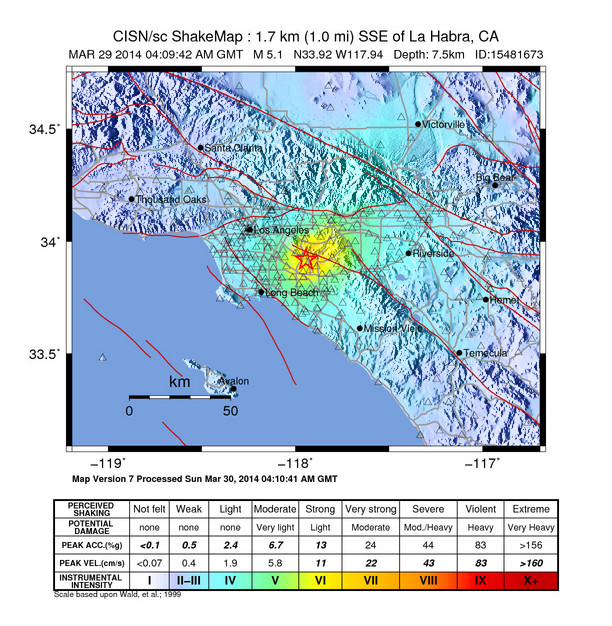
A M5.1 earthquake occurred at 9:09PM on March 28, 2014, located 1 mile east of La Habra, CA, or 4 miles north of Fullerton, CA. The event was felt widely throughout Orange, Los Angeles, Ventura, Riverside, and San Bernardino counties. It was preceded by two foreshocks, the larger of M3.6 at 8:03pm. The demonstration earthquake early warning system provided 4 second warning in Pasadena.
There have been 29 aftershocks as of 10:11PM, the largest of which was a M3.6 at 9:30PM, and was felt locally near the epicenter. The aftershock sequence may continue for several days to weeks, but the number of aftershocks and magnitude will decay as time goes by.
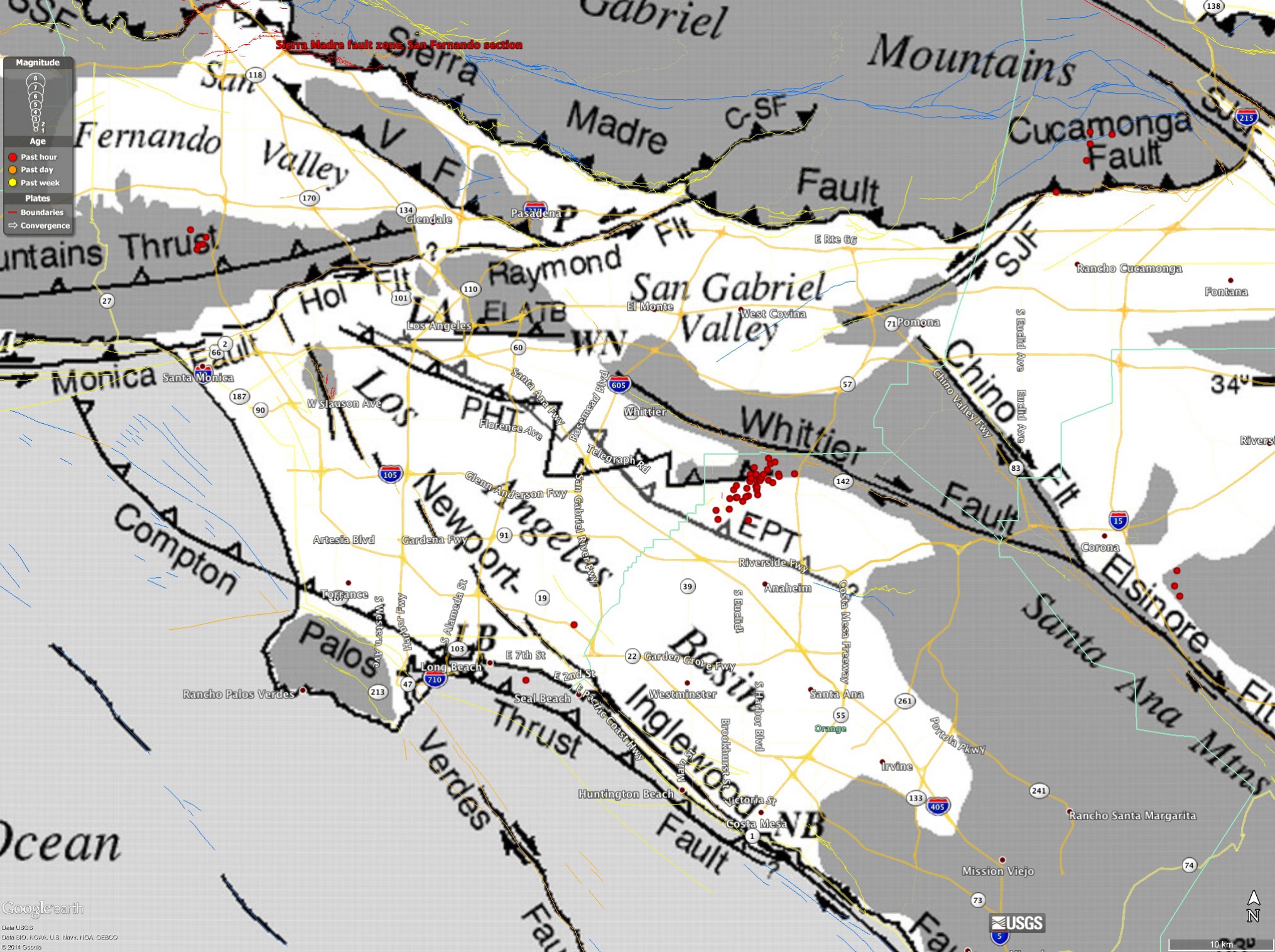
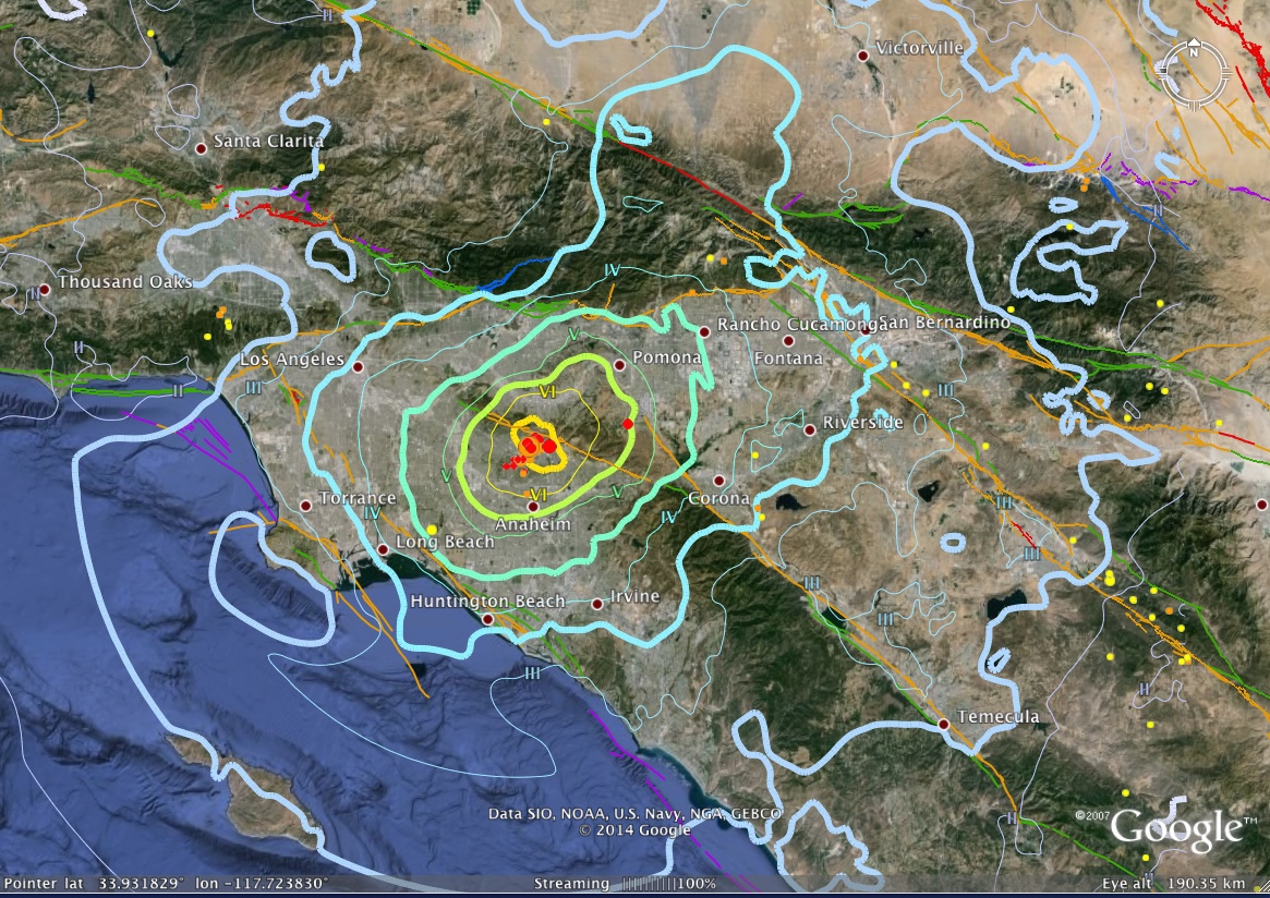
The maximum observed instrumental intensity was VII, recorded in the LA Habra and Brea areas, although the ShakeMap shows a wide area of maximum intensity of VI. The maximum reported intensity for the Community Internet Intensity Map (Did You Feel It?) was reported at VII in the epicentral area. The CIIM map is shown below.
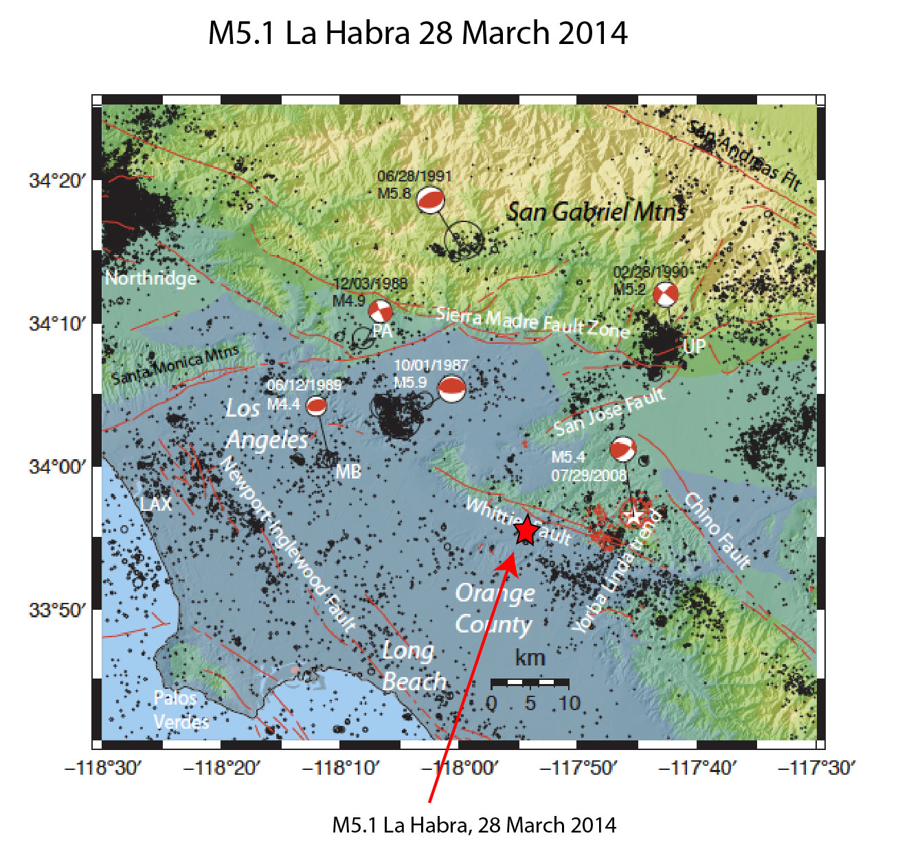
This sequence could be associated with the Puente Hills thrust (PHT). The PHT is a blind thrust fault that extends from this region to the north and west towards the City of Los Angeles. It caused the M5.9 1987 Oct. 1 Whittier Narrows earthquake.
Previously, the M5.4 2008 Chino Hills earthquake occurred in this region. It caused somewhat stronger shaking in Orange County and across the Los Angeles Basin.
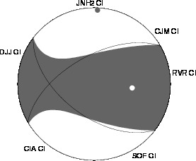
The moment tensor shows oblique faulting, with a north dipping plane that approximately aligns with the Puente Hills thrust. The hypocentral depth was 7.5 km.
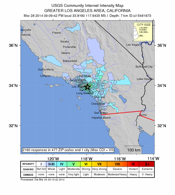
The maximum observed instrumental intensity was VI, recorded in Brea and La Habra, and the maximum reported intensity for the Community Internet Intensity Map (Did You Feel It?) was reported at VII in the epicentral area. The CIIM map is shown below.
Approximately 5% of all earthquakes in Southern California are foreshocks for larger events, although this probability decays rapidly with time. This sequence fits the more rare foreshock/mainshock sequence, as the M5.1 mainshock was preceeded by a M3.6 foreshock. Sometimes larger earthquakes may function as triggers for more distant earthquakes, but generally those events are very large.
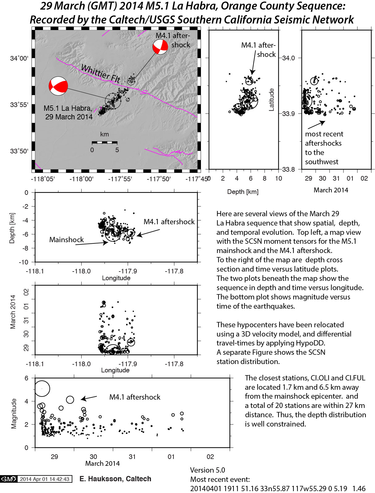
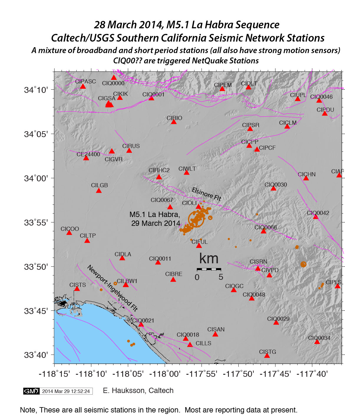
The aftershock distribution is bi-lateral, extending about 4km to the NE and NW away from the mainshock epicenter. The mainshock occurred at a depth of 6.2 km.
The M4.1 aftershock at 2:32pm (local time) has also been relocated. It is located at the very north east end of the aftershock zone at a depth of 7.2 km. This is a new development in this sequence, and indicates growth of the aftershock zone to the northeast.
The southwest striking nodal plane coincides with the aftershock distribution, defining a northeast striking fault with a mixture of strike-slip and thrust faulting.
AFTERSHOCK PROBABILITY REPORT
Aftershock counts at 14 hours past the mainshock; given 3 M>=3 aftershocks and 9>=2.5 the sequence is very closely on target for mean expected aftershock rates in California. Projecting forwards gives a 2% chance of a larger aftershock from this point over the next 7 days, and a 3% chance for such an event over the next year.
This situation with two notable quakes happening only 12 days apart is similar to the Yucaipa and Anza earthquake pair in 2005 which were separated by 4 days and a reasonable amount of distance. The conventional projected aftershock triggering rate was calculated for the Yucaipa event at the location of the Anza event 4 days later it was actually much smaller than the background rate at Anza, indicating that the coincidence of the events had likely been pure chance. Given a 12 day separation here, the same calculation would likely give similar results. Aftershock triggering usually results from a critical partnering of both dynamic accelerations and aseismic afterslip, so there could be a general rate increase and/or a general increase in the aftershock triggering rate over a region in which a prior quake, or some other force, has caused aseismic slip and the incidence of slow earthquakes to increase. Pure dynamic triggering from surface waves could also be involved. We know from experience that when more earthquakes happen more earthquakes tend to happen; but we also know that these clusters often manage to elude statistical significance. With the present state of knowledge there is nothing quantitative we can say at present besides the 3% value for the immediate aftershock zone. Future research is required, and any updated information will be added as it becomes available.