Olancha Earthquake Sequence Continues – 435 Events Through October 7th, Activity Beginning Oct. 3rd Reveals New Structure Orthogonal to Previous Olancha Sequence Structures
Report by the California Integrated Seismic Network (Caltech/USGS)
Anthony Guarino, Egill Hauksson, Ken Hudnut, Sue Hough, and Bob Dollar
Update 10/7/09 09:21AM PDT
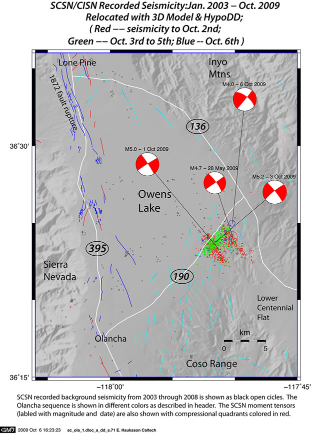
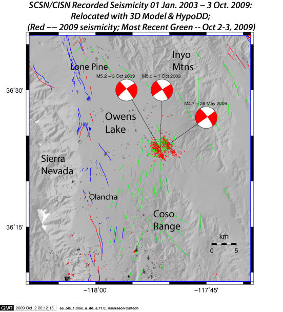
The Olancha Sequence continues with several more events since Friday evening, ranging in magnitude from M1.0-M4.5. The events beginning October 3rd distinctly show a new trend on a cross fault between the two existing structures. The two existing structures trend NW-SE, whereas the new Oct. 3rd events trend southwest to northeast. This new structure is likely a conjugate fault with respect to the existing structures, as the geology in the area is rather complex.
The migration of activity toward the new structure offers insight to the complex geology of the area, although the trend of mapped faults (shown in light blue) do not share the same strike as either of the previous structures from this week, nor are they orthogonal to the newest structure. The recent M4.0 earthquake which occurred on October 6th was located on the most northeast edge of the sequence. This extends the region of seismicity slightly to the northeast, while the event is still part of the more recent SW-NE trend.
Northwestward motion of the Pacific Plate, relative to a fixed North American Plate, takes place mainly on the San Andreas fault system and other faults to the west of the Sierra Nevada. A portion of the deformation, however, passes inboard of the Sierra Nevada block and goes up the eastern side of the Sierra Nevada. The Sierra Nevada have been moving slowly northwestward as a result, pulling away from the Colorado Plateau. The Basin and Range Province has resulted from this crustal stretching, and some right-lateral shear along the eastern base of the Sierra Nevada occurs as well.
The Olancha activity, occurring on both NW-SE and SW-NE oriented faults, is taking place in a complex area where the Sierra Nevada range front also bends. This bend, combined with the right-lateral shear along the range front, has produced an extensional step in the fault system and the hole created has been filled with a sedimentary basin that is now filled by Owens Lake, which is now, for the most part, a playa or dry lake bed. Interestingly, this bend in the mountain range front also coincides with the highest peak, Mount Whitney, and the recent Olancha activity is near the southern end of the 1872 Owens Valley earthquake, which ruptured a system of faults that run through Lone Pine [https://earthquake.usgs.gov/regional/states/events/1872_03_26.php ].

The peak reported intensity from the CIIM reports was MMI IV, reported in the towns of Onyx and Lone Pine, 84 km and 62 km away from the epicenter, respectfully. Felt reports were distributed similar to the instrumental intensity observed.

| Ev ID | Mag | Date Time | Lat | Lon | Depth | Location |
|---|---|---|---|---|---|---|
| 14517500 | 5 | 10/1/2009 3:01:24 | 36 23.3 N | 117 51.5 W | 5.6 | 18 km (11 mi) NE of Olancha, CA |
| 14517508 | 3.5 | 10/1/2009 3:03:30 | 36 22.5 N | 117 51.6 W | 5.9 | 17 km (10 mi) NE of Olancha, CA |
| 14517516 | 2.8 | 10/1/2009 3:04:31 | 36 24.1 N | 117 52.4 W | 5.6 | 18 km (11 mi) NE of Olancha, CA |
| 14517548 | 2.7 | 10/1/2009 3:10:26 | 36 22.6 N | 117 51.1 W | 2.7 | 17 km (11 mi) NE of Olancha, CA |
| 14517700 | 2.8 | 10/1/2009 3:48:42 | 36 22.6 N | 117 51.4 W | 2.3 | 17 km (11 mi) NE of Olancha, CA |
| 14517796 | 3.4 | 10/1/2009 4:32:23 | 36 23.3 N | 117 51.5 W | 4.3 | 18 km (11 mi) NE of Olancha, CA |
| 10133126 | 3.3 | 10/1/2009 4:32:52 | 36 22.8 N | 117 51.7 W | 6 | 17 km (11 mi) NE of Olancha, CA |
| 14517820 | 2.8 | 10/1/2009 4:53:04 | 36 23.8 N | 117 52 W | 1.9 | 18 km (11 mi) NE of Olancha, CA |
| 14517876 | 2.8 | 10/1/2009 5:26:17 | 36 23.4 N | 117 50.5 W | 1.6 | 19 km (12 mi) NE of Olancha, CA |
| 14517908 | 3.5 | 10/1/2009 5:55:55 | 36 22.6 N | 117 51.2 W | 2.1 | 17 km (11 mi) NE of Olancha, CA |
| 14517916 | 3.4 | 10/1/2009 5:56:33 | 36 23 N | 117 50.7 W | 5.7 | 18 km (11 mi) NE of Olancha, CA |
| 14517940 | 2.8 | 10/1/2009 6:13:08 | 36 22.8 N | 117 51.2 W | 5.6 | 17 km (11 mi) NE of Olancha, CA |
| 14517972 | 2.8 | 10/1/2009 6:34:50 | 36 22.9 N | 117 51.7 W | 3.4 | 17 km (11 mi) NE of Olancha, CA |
| 14518108 | 3.5 | 10/1/2009 8:08:12 | 36 23.7 N | 117 52.1 W | 4.1 | 18 km (11 mi) NE of Olancha, CA |
| 14518396 | 2.6 | 10/1/2009 13:07:39 | 36 22.2 N | 117 51.2 W | 2.1 | 17 km (10 mi) NE of Olancha, CA |
| 14518452 | 2.8 | 10/1/2009 13:45:37 | 36 24.1 N | 117 52.5 W | 5.6 | 18 km (11 mi) NE of Olancha, CA |
| 14518644 | 2.7 | 10/1/2009 16:22:43 | 36 23.3 N | 117 51.3 W | 2.5 | 18 km (11 mi) NE of Olancha, CA |
| 14518924 | 2.7 | 10/2/2009 0:21:00 | 36 23 N | 117 51.8 W | 4.2 | 17 km (11 mi) NE of Olancha, CA |
| 14519612 | 2.7 | 10/2/2009 16:28:06 | 36 23.4 N | 117 52.1 W | 4.2 | 17 km (11 mi) NE of Olancha, CA |
| 14519700 | 3.1 | 10/2/2009 17:32:05 | 36 23.4 N | 117 51.7 W | 2.2 | 18 km (11 mi) NE of Olancha, CA |
| 14519756 | 4.7 | 10/2/2009 18:09:19 | 36 23.5 N | 117 51.8 W | 2.5 | 18 km (11 mi) NE of Olancha, CA |
| 14519764 | 4.9 | 10/2/2009 18:10:26 | 36 23.2 N | 117 52.1 W | 3.6 | 17 km (11 mi) NE of Olancha, CA |
| 14519780 | 5.2 | 10/2/2009 18:16:00 | 36 23.5 N | 117 51.6 W | 0 | 18 km (11 mi) NE of Olancha, CA |
| 10133842 | 2.5 | 10/2/2009 18:18:20 | 36 23.7 N | 117 51.7 W | 7 | 18 km (11 mi) NE of Olancha, CA |
| 10133850 | 2.8 | 10/2/2009 18:19:02 | 36 23.1 N | 117 52.7 W | 5.6 | 16 km (10 mi) NE of Olancha, CA |
| 14519796 | 2.8 | 10/2/2009 18:19:50 | 36 23.6 N | 117 51.8 W | 5.6 | 18 km (11 mi) NE of Olancha, CA |
| 14519820 | 2.7 | 10/2/2009 18:23:26 | 36 24.2 N | 117 50.4 W | 0.6 | 20 km (12 mi) NE of Olancha, CA |
| 14519844 | 2.8 | 10/2/2009 18:26:05 | 36 22.9 N | 117 51.7 W | 2 | 17 km (11 mi) NE of Olancha, CA |
| 14519860 | 4.1 | 10/2/2009 18:30:31 | 36 24.2 N | 117 51.1 W | 1.7 | 19 km (12 mi) NE of Olancha, CA |
| 14519868 | 4 | 10/2/2009 18:31:44 | 36 24.3 N | 117 50.8 W | 2.5 | 20 km (12 mi) NE of Olancha, CA |
| 14519876 | 3.4 | 10/2/2009 18:33:35 | 36 24 N | 117 50.9 W | 0.9 | 19 km (12 mi) NE of Olancha, CA |
| 14519900 | 3.3 | 10/2/2009 18:38:09 | 36 24.5 N | 117 51.3 W | 4.8 | 20 km (12 mi) NE of Olancha, CA |
| 14519948 | 2.8 | 10/2/2009 18:42:30 | 36 23.6 N | 117 51 W | 1.9 | 19 km (12 mi) NE of Olancha, CA |
| 14519940 | 4.2 | 10/2/2009 18:47:55 | 36 23.7 N | 117 50.7 W | 1.7 | 19 km (12 mi) NE of Olancha, CA |
| 14519956 | 2.5 | 10/2/2009 18:50:21 | 36 22.8 N | 117 52 W | 2.4 | 16 km (10 mi) NE of Olancha, CA |
| 14519964 | 2.9 | 10/2/2009 18:52:17 | 36 24.3 N | 117 50.6 W | 1.9 | 20 km (12 mi) NE of Olancha, CA |
| 14519980 | 3 | 10/2/2009 18:56:00 | 36 23.1 N | 117 50.5 W | 1.6 | 19 km (12 mi) NE of Olancha, CA |
| 10134482 | 2.5 | 10/2/2009 18:59:46 | 36 22.6 N | 117 52.8 W | 5.6 | 15 km (10 mi) NE of Olancha, CA |
| 14520052 | 3.4 | 10/2/2009 19:27:06 | 36 23.2 N | 117 50.6 W | 2 | 19 km (12 mi) NE of Olancha, CA |
| 14520172 | 3.1 | 10/2/2009 20:11:17 | 36 24.6 N | 117 51.3 W | 1.8 | 20 km (12 mi) NE of Olancha, CA |
| 14520244 | 2.7 | 10/2/2009 20:37:41 | 36 23.3 N | 117 52 W | 3.5 | 17 km (11 mi) NE of Olancha, CA |
| 14520292 | 2.5 | 10/2/2009 20:54:48 | 36 23.9 N | 117 52.5 W | 5.8 | 18 km (11 mi) NE of Olancha, CA |
| 14520324 | 2.6 | 10/2/2009 21:23:41 | 36 24.4 N | 117 51.2 W | 2.3 | 19 km (12 mi) NE of Olancha, CA |
| 14520420 | 2.6 | 10/2/2009 22:05:33 | 36 24 N | 117 52.1 W | 5.1 | 18 km (11 mi) NE of Olancha, CA |
| 14520476 | 4.7 | 10/2/2009 22:31:57 | 36 23.7 N | 117 52.1 W | 1.6 | 18 km (11 mi) NE of Olancha, CA |
| 14520484 | 2.9 | 10/2/2009 22:38:41 | 36 23.1 N | 117 51.6 W | 0.5 | 17 km (11 mi) NE of Olancha, CA |
| 14520556 | 3 | 10/2/2009 23:15:39 | 36 23 N | 117 52.9 W | 2.2 | 16 km (10 mi) NE of Olancha, CA |
| 14520580 | 2.9 | 10/2/2009 23:30:46 | 36 23.3 N | 117 52.3 W | 2.7 | 17 km (10 mi) NE of Olancha, CA |
| 14520812 | 2.8 | 10/3/2009 2:25:53 | 36 24.7 N | 117 51 W | 3.9 | 20 km (12 mi) NE of Olancha, CA |
| 14520900 | 4.5 | 10/3/2009 4:37:10 | 36 23.4 N | 117 52.4 W | 1.2 | 17 km (11 mi) NE of Olancha, CA |
| 14520972 | 2.9 | 10/3/2009 5:41:13 | 36 22.3 N | 117 50.9 W | 0.1 | 17 km (11 mi) NE of Olancha, CA |
| 14521076 | 3 | 10/3/2009 8:10:35 | 36 23.1 N | 117 52.5 W | 0.3 | 16 km (10 mi) NE of Olancha, CA |
| 14521148 | 3.1 | 10/3/2009 9:22:32 | 36 23.2 N | 117 52.6 W | 4.3 | 16 km (10 mi) NE of Olancha, CA |
| 14521204 | 3 | 10/3/2009 10:52:31 | 36 23.7 N | 117 51.1 W | 3.3 | 19 km (12 mi) NE of Olancha, CA |
| 14521396 | 2.5 | 10/3/2009 14:54:29 | 36 23.4 N | 117 52.3 W | 2.8 | 17 km (11 mi) NE of Olancha, CA |
| 14521500 | 2.9 | 10/3/2009 17:07:37 | 36 24.9 N | 117 50.5 W | 5.7 | 21 km (13 mi) NE of Olancha, CA |
| 14521564 | 3.5 | 10/3/2009 18:02:09 | 36 23.3 N | 117 51.8 W | 2.7 | 17 km (11 mi) NE of Olancha, CA |
| 14521572 | 2.8 | 10/3/2009 18:08:35 | 36 22.9 N | 117 51.9 W | 1.7 | 17 km (10 mi) NE of Olancha, CA |
| 14521676 | 2.8 | 10/3/2009 19:50:48 | 36 23.2 N | 117 51.4 W | 2.6 | 18 km (11 mi) NE of Olancha, CA |
| 14522164 | 2.9 | 10/4/2009 3:24:18 | 36 23.2 N | 117 52 W | 5.2 | 17 km (11 mi) NE of Olancha, CA |
| 14522292 | 2.8 | 10/4/2009 7:54:51 | 36 24.3 N | 117 51.2 W | 5.8 | 19 km (12 mi) NE of Olancha, CA |
| 14522356 | 2.7 | 10/4/2009 9:47:28 | 36 22.8 N | 117 51.1 W | 4 | 18 km (11 mi) NE of Olancha, CA |
| 14522484 | 2.8 | 10/4/2009 14:59:28 | 36 23.3 N | 117 51.7 W | 0.9 | 17 km (11 mi) NE of Olancha, CA |
| 14523308 | 2.8 | 10/5/2009 20:24:48 | 36 23.9 N | 117 51 W | 3.5 | 19 km (12 mi) NE of Olancha, CA |
| 14523588 | 2.6 | 10/6/2009 9:31:15 | 36 24.5 N | 117 52.5 W | 4.2 | 18 km (11 mi) NE of Olancha, CA |
| 14523676 | 4 | 10/6/2009 11:06:34 | 36 24.9 N | 117 50.1 W | 1.7 | 21 km (13 mi) NE of Olancha, CA |
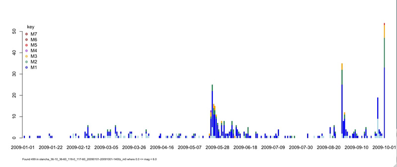
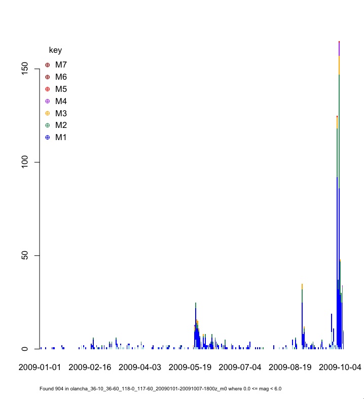
Events in this area have spawned robust aftershock sequences in the past, and earthquake swarms for this area are not uncommon. The distribution of events so far may be seen below in the graph, showing other recent significant sequences. This plot is current as of 11:15AM PDT 10/7/09.
Update 10/5/09 01:49PM PDT
Olancha Earthquake Sequence Continues – 356 Events to date, Activity Beginning Oct. 3rd Reveals New Structure Orthogonal to Previous Olancha Sequence Structures
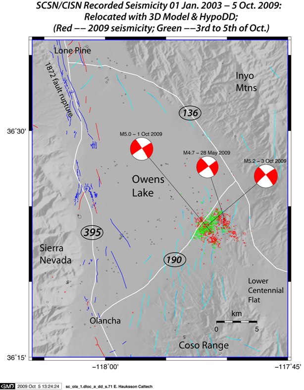
The Olancha Sequence continues with several more events since Friday evening, ranging in magnitude from M1.0-M4.5. The events beginning October 3rd distinctly show a new trend on a cross fault between the two existing structures. The two existing structures trend NW-SE, whereas the new Oct. 3rd events trend southwest to northeast. This new structure is likely a conjugate fault with respect to the existing structures, as the geology in the area is rather complex.
The migration of activity toward the new structure offers insight to the complex geology of the area, although the trend of mapped faults (shown in light blue) do not share the same strike as either of the previous structures from this week, nor are they orthogonal to the newest structure.
List of M2.5+ Events for the Olancha Sequence (through 10/5/09 1:52PM)
| Ev ID | Mag | Date Time | Lat | Lon | Depth | Location |
|---|---|---|---|---|---|---|
| 14517500 | 5 | 10/1/2009 3:01:24 | 36 23.3 N | 117 51.5 W | 5.6 | 18 km (11 mi) NE of Olancha, CA |
| 14517508 | 3.5 | 10/1/2009 3:03:30 | 36 22.5 N | 117 51.6 W | 5.9 | 17 km (10 mi) NE of Olancha, CA |
| 14517516 | 2.8 | 10/1/2009 3:04:31 | 36 24.1 N | 117 52.4 W | 5.6 | 18 km (11 mi) NE of Olancha, CA |
| 14517548 | 2.7 | 10/1/2009 3:10:26 | 36 22.6 N | 117 51.1 W | 2.7 | 17 km (11 mi) NE of Olancha, CA |
| 14517700 | 2.8 | 10/1/2009 3:48:42 | 36 22.6 N | 117 51.4 W | 2.3 | 17 km (11 mi) NE of Olancha, CA |
| 14517796 | 3.4 | 10/1/2009 4:32:23 | 36 23.3 N | 117 51.5 W | 4.3 | 18 km (11 mi) NE of Olancha, CA |
| 10133126 | 3.3 | 10/1/2009 4:32:52 | 36 22.8 N | 117 51.7 W | 6 | 17 km (11 mi) NE of Olancha, CA |
| 14517820 | 2.8 | 10/1/2009 4:53:04 | 36 23.8 N | 117 52 W | 1.9 | 18 km (11 mi) NE of Olancha, CA |
| 14517876 | 2.8 | 10/1/2009 5:26:17 | 36 23.4 N | 117 50.5 W | 1.6 | 19 km (12 mi) NE of Olancha, CA |
| 14517908 | 3.5 | 10/1/2009 5:55:55 | 36 22.6 N | 117 51.2 W | 2.1 | 17 km (11 mi) NE of Olancha, CA |
| 14517916 | 3.4 | 10/1/2009 5:56:33 | 36 23 N | 117 50.7 W | 5.7 | 18 km (11 mi) NE of Olancha, CA |
| 14517940 | 2.8 | 10/1/2009 6:13:08 | 36 22.8 N | 117 51.2 W | 5.6 | 17 km (11 mi) NE of Olancha, CA |
| 14517972 | 2.8 | 10/1/2009 6:34:50 | 36 22.9 N | 117 51.7 W | 3.4 | 17 km (11 mi) NE of Olancha, CA |
| 14518108 | 3.5 | 10/1/2009 8:08:12 | 36 23.7 N | 117 52.1 W | 4.1 | 18 km (11 mi) NE of Olancha, CA |
| 14518396 | 2.6 | 10/1/2009 13:07:39 | 36 22.2 N | 117 51.2 W | 2.1 | 17 km (10 mi) NE of Olancha, CA |
| 14518452 | 2.8 | 10/1/2009 13:45:37 | 36 24.1 N | 117 52.5 W | 5.6 | 18 km (11 mi) NE of Olancha, CA |
| 14518644 | 2.7 | 10/1/2009 16:22:43 | 36 23.3 N | 117 51.3 W | 2.5 | 18 km (11 mi) NE of Olancha, CA |
| 14518924 | 2.7 | 10/2/2009 0:21:00 | 36 23 N | 117 51.8 W | 4.2 | 17 km (11 mi) NE of Olancha, CA |
| 14519612 | 2.7 | 10/2/2009 16:28:06 | 36 23.4 N | 117 52.1 W | 4.2 | 17 km (11 mi) NE of Olancha, CA |
| 14519700 | 3.1 | 10/2/2009 17:32:05 | 36 23.4 N | 117 51.7 W | 2.2 | 18 km (11 mi) NE of Olancha, CA |
| 14519756 | 4.7 | 10/2/2009 18:09:18 | 36 23.1 N | 117 51.8 W | 0.1 | 17 km (11 mi) NE of Olancha, CA |
| 14519764 | 4.9 | 10/2/2009 18:10:25 | 36 23.2 N | 117 52 W | 3.6 | 17 km (11 mi) NE of Olancha, CA |
| 14519780 | 5.2 | 10/2/2009 18:15:59 | 36 23.6 N | 117 52.6 W | 0.1 | 17 km (10 mi) NE of Olancha, CA |
| 14519796 | 2.8 | 10/2/2009 18:19:50 | 36 23.4 N | 117 51.6 W | 6 | 18 km (11 mi) NE of Olancha, CA |
| 14519812 | 2.6 | 10/2/2009 18:22:28 | 36 24.1 N | 117 51.1 W | 5.2 | 19 km (12 mi) NE of Olancha, CA |
| 14519820 | 2.7 | 10/2/2009 18:23:26 | 36 24.9 N | 117 51 W | 4.3 | 20 km (13 mi) NE of Olancha, CA |
| 14519844 | 2.8 | 10/2/2009 18:26:05 | 36 23.2 N | 117 52.4 W | 2.6 | 17 km (10 mi) NE of Olancha, CA |
| 14519860 | 4.1 | 10/2/2009 18:30:31 | 36 24.3 N | 117 51.8 W | 3.5 | 19 km (12 mi) NE of Olancha, CA |
| 14519868 | 4 | 10/2/2009 18:31:43 | 36 23.8 N | 117 51.5 W | 0 | 18 km (11 mi) NE of Olancha, CA |
| 14519876 | 3.4 | 10/2/2009 18:33:35 | 36 24.3 N | 117 51 W | 2.3 | 20 km (12 mi) NE of Olancha, CA |
| 14519900 | 3.3 | 10/2/2009 18:38:08 | 36 24.6 N | 117 51.7 W | 5.7 | 19 km (12 mi) NE of Olancha, CA |
| 14519908 | 2.8 | 10/2/2009 18:42:17 | 36 24.1 N | 117 51.9 W | 2.8 | 18 km (11 mi) NE of Olancha, CA |
| 14519940 | 4.2 | 10/2/2009 18:47:54 | 36 23.7 N | 117 51.3 W | 0.3 | 18 km (11 mi) NE of Olancha, CA |
| 14519956 | 2.7 | 10/2/2009 18:50:21 | 36 23.2 N | 117 52.4 W | 4.8 | 16 km (10 mi) NE of Olancha, CA |
| 14519964 | 2.8 | 10/2/2009 18:52:17 | 36 24.3 N | 117 50.5 W | 0.7 | 20 km (12 mi) NE of Olancha, CA |
| 14519980 | 3 | 10/2/2009 18:56:00 | 36 23.2 N | 117 50.8 W | 4.1 | 18 km (11 mi) NE of Olancha, CA |
| 14520004 | 2.5 | 10/2/2009 18:59:35 | 36 24 N | 117 52.4 W | 6.4 | 18 km (11 mi) NE of Olancha, CA |
| 14520052 | 3.3 | 10/2/2009 19:27:06 | 36 23 N | 117 51.2 W | 3.8 | 18 km (11 mi) NE of Olancha, CA |
| 14520172 | 3.1 | 10/2/2009 20:11:17 | 36 24.6 N | 117 51.3 W | 1.8 | 20 km (12 mi) NE of Olancha, CA |
| 14520244 | 2.7 | 10/2/2009 20:37:41 | 36 23.3 N | 117 52 W | 3.5 | 17 km (11 mi) NE of Olancha, CA |
| 14520292 | 2.5 | 10/2/2009 20:54:48 | 36 23.9 N | 117 52.5 W | 5.8 | 18 km (11 mi) NE of Olancha, CA |
| 14520324 | 2.6 | 10/2/2009 21:23:41 | 36 24.4 N | 117 51.2 W | 2.3 | 19 km (12 mi) NE of Olancha, CA |
| 14520420 | 2.6 | 10/2/2009 22:05:33 | 36 24 N | 117 52.1 W | 5.1 | 18 km (11 mi) NE of Olancha, CA |
| 14520476 | 4.7 | 10/2/2009 22:31:57 | 36 23.7 N | 117 52.1 W | 1.6 | 18 km (11 mi) NE of Olancha, CA |
| 14520484 | 2.9 | 10/2/2009 22:38:41 | 36 23.1 N | 117 51.6 W | 0.5 | 17 km (11 mi) NE of Olancha, CA |
| 14520556 | 3 | 10/2/2009 23:15:39 | 36 23 N | 117 52.9 W | 2.2 | 16 km (10 mi) NE of Olancha, CA |
| 14520580 | 2.9 | 10/2/2009 23:30:46 | 36 23.3 N | 117 52.3 W | 2.7 | 17 km (10 mi) NE of Olancha, CA |
| 14520812 | 2.8 | 10/3/2009 2:25:53 | 36 24.7 N | 117 51 W | 3.9 | 20 km (12 mi) NE of Olancha, CA |
| 14520900 | 4.5 | 10/3/2009 4:37:10 | 36 23.4 N | 117 52.4 W | 1.2 | 17 km (11 mi) NE of Olancha, CA |
| 14520972 | 2.9 | 10/3/2009 5:41:13 | 36 22.3 N | 117 50.9 W | 0.1 | 17 km (11 mi) NE of Olancha, CA |
| 14521076 | 3 | 10/3/2009 8:10:35 | 36 23.1 N | 117 52.5 W | 0.3 | 16 km (10 mi) NE of Olancha, CA |
| 14521148 | 3.1 | 10/3/2009 9:22:32 | 36 23.2 N | 117 52.6 W | 4.3 | 16 km (10 mi) NE of Olancha, CA |
| 14521204 | 3 | 10/3/2009 10:52:31 | 36 23.7 N | 117 51.1 W | 3.3 | 19 km (12 mi) NE of Olancha, CA |
| 14521396 | 2.5 | 10/3/2009 14:54:29 | 36 23.4 N | 117 52.3 W | 2.8 | 17 km (11 mi) NE of Olancha, CA |
| 14521500 | 2.9 | 10/3/2009 17:07:37 | 36 25.1 N | 117 50.7 W | 7.2 | 21 km (13 mi) NE of Olancha, CA |
| 14521564 | 3.5 | 10/3/2009 18:02:08 | 36 23.1 N | 117 52.1 W | 0.4 | 17 km (10 mi) NE of Olancha, CA |
| 14521572 | 2.8 | 10/3/2009 18:08:35 | 36 22.9 N | 117 51.9 W | 1.7 | 17 km (10 mi) NE of Olancha, CA |
| 14522164 | 2.9 | 10/4/2009 3:24:18 | 36 23.2 N | 117 52 W | 5.2 | 17 km (11 mi) NE of Olancha, CA |
| 14522292 | 2.8 | 10/4/2009 7:54:51 | 36 24.3 N | 117 51.2 W | 5.8 | 19 km (12 mi) NE of Olancha, CA |
| 14522356 | 2.7 | 10/4/2009 9:47:28 | 36 22.8 N | 117 51.1 W | 4 | 18 km (11 mi) NE of Olancha, CA |
| 14522484 | 2.8 | 10/4/2009 14:59:28 | 36 23.3 N | 117 51.7 W | 0.9 | 17 km (11 mi) NE of Olancha, CA |
Update 10/2/09 07:53PM PDT
A Mw5.2 Earthquake occurred in the same area where the Olancha Earthquake Sequence continues. The Mw5.2 event occurred at 6:14PM PDT on October 2, 2009, and was preceded immediately by a M4.7 at 6:09PM and a M4.9 at 6:10PM. These events were all located in the same general area, 18 km NE of Olancha, CA. These three earthquakes are just a few in a larger sequence of events that began on 10/1/09 with a Mw5.0 earthquake at 03:01AM PDT on 10/1/09, that occurred 17.6km NE of Olancha, CA. This was then followed by a robust sequence, with events ranging from M1.0 to the recent Mw5.2. The list below compiles all events M2.5 and larger.
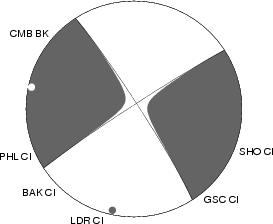
The moment tensor solution for the Mw5.2 event displays right-lateral strike-slip motion on a nodal plane striking N38W. This is similar to the moment tensor solution for the Mw5.0 that occurred in this area yesterday morning. The Hauksson-Shearer relocations display multiple NW striking sub-parallel faults rupturing and some NE cross faulting happening within a small crustal volume.
Felt reports for the Mw5.2 have been distributed widely throughout southern, central, and northern California. Reports from the epicentral region range in intensity from III to MMI VI. SCSN stations report peak horizontal acceleration ranging from 3.63%g at Lone Pine to 8.62%g at Owens Valley. Peak instrumental intensity for this event is MMI V.
Olancha Earthquake Sequence M2.5+ Events:
| Mag | Date Time | Lat | Lon | Depth | Location |
|---|---|---|---|---|---|
| 5 | 10/1/2009 3:01:24 | 36.388N | 117.859W | 5.6 | 11 km (7 mi) S of Keeler, CA |
| 3.5 | 10/1/2009 8:08:12 | 36.394N | 117.869W | 4 | 10 km (6 mi) S of Keeler, CA |
| 3.5 | 10/1/2009 5:55:55 | 36.377N | 117.854W | 2 | 12 km (8 mi) S of Keeler, CA |
| 3.5 | 10/1/2009 3:03:30 | 36.376N | 117.860W | 5.9 | 13 km (8 mi) S of Keeler, CA |
| 3.4 | 10/1/2009 5:56:33 | 36.383N | 117.844W | 5.6 | 12 km (7 mi) SSE of Keeler, CA |
| 3.4 | 10/1/2009 4:32:23 | 36.389N | 117.859W | 4.2 | 11 km (7 mi) S of Keeler, CA |
| 3.3 | 10/1/2009 4:32:52 | 36.380N | 117.861W | 6 | 12 km (7 mi) S of Keeler, CA |
| 2.8 | 10/1/2009 13:45:37 | 36.401N | 117.875W | 5.5 | 10 km (6 mi) S of Keeler, CA |
| 2.8 | 10/1/2009 6:34:50 | 36.382N | 117.862W | 3.4 | 12 km (7 mi) S of Keeler, CA |
| 2.8 | 10/1/2009 6:13:08 | 36.380N | 117.853W | 5.6 | 12 km (8 mi) S of Keeler, CA |
| 2.8 | 10/1/2009 5:26:17 | 36.390N | 117.841W | 1.6 | 11 km (7 mi) SSE of Keeler, CA |
| 2.8 | 10/1/2009 4:53:04 | 36.397N | 117.866W | 1.8 | 10 km (6 mi) S of Keeler, CA |
| 2.8 | 10/1/2009 3:48:42 | 36.377N | 117.857W | 2.2 | 12 km (8 mi) S of Keeler, CA |
| 2.8 | 10/1/2009 3:04:31 | 36.402N | 117.874W | 5.6 | 10 km (6 mi) S of Keeler, CA |
| 2.7 | 10/1/2009 16:22:43 | 36.388N | 117.856W | 2.5 | 11 km (7 mi) S of Keeler, CA |
| 2.7 | 10/1/2009 3:10:26 | 36.377N | 117.852W | 2.7 | 12 km (8 mi) S of Keeler, CA |
| 2.6 | 10/1/2009 13:07:39 | 36.370N | 117.853W | 2.1 | 13 km (8 mi) S of Keeler, CA |
| 2.5 | 10/1/2009 7:21:35 | 36.376N | 117.854W | 5.6 | 13 km (8 mi) S of Keeler, CA |
| 5.2 | 10/2/2009 18:15:59 | 36.393N | 117.877W | 0 | 11 km (7 mi) S of Keeler, CA |
| 4.9 | 10/2/2009 18:10:25 | 36.386N | 117.867W | 3.6 | 11 km (7 mi) S of Keeler, CA |
| 4.7 | 10/2/2009 18:09:18 | 36.385N | 117.864W | 0.1 | 11 km (7 mi) S of Keeler, CA |
| 4.2 | 10/2/2009 18:47:54 | 36.395N | 117.855W | 0.2 | 10 km (6 mi) S of Keeler, CA |
| 4.1 | 10/2/2009 18:30:31 | 36.405N | 117.863W | 3.5 | 9 km (6 mi) S of Keeler, CA |
| 4 | 10/2/2009 18:31:43 | 36.397N | 117.858W | 0 | 10 km (6 mi) S of Keeler, CA |
| 3.4 | 10/2/2009 18:33:35 | 36.404N | 117.849W | 2.3 | 10 km (6 mi) SSE of Keeler, CA |
| 3.3 | 10/2/2009 19:27:06 | 36.383N | 117.853W | 3.8 | 12 km (7 mi) S of Keeler, CA |
| 3.3 | 10/2/2009 18:38:08 | 36.409N | 117.862W | 5.7 | 9 km (5 mi) S of Keeler, CA |
| 3.1 | 10/2/2009 20:11:17 | 36.410N | 117.854W | 1.8 | 9 km (6 mi) S of Keeler, CA |
| 3.1 | 10/2/2009 17:32:04 | 36.386N | 117.868W | 0.9 | 11 km (7 mi) S of Keeler, CA |
| 3 | 10/2/2009 18:56:00 | 36.387N | 117.847W | 4.1 | 11 km (7 mi) S of Keeler, CA |
| 2.8 | 10/2/2009 18:52:17 | 36.406N | 117.842W | 0.6 | 10 km (6 mi) SSE of Keeler, CA |
| 2.8 | 10/2/2009 18:42:17 | 36.402N | 117.864W | 2.7 | 10 km (6 mi) S of Keeler, CA |
| 2.8 | 10/2/2009 18:26:05 | 36.386N | 117.873W | 2.5 | 11 km (7 mi) S of Keeler, CA |
| 2.8 | 10/2/2009 18:19:50 | 36.389N | 117.860W | 6 | 11 km (7 mi) S of Keeler, CA |
| 2.7 | 10/2/2009 20:37:41 | 36.389N | 117.867W | 3.5 | 11 km (7 mi) S of Keeler, CA |
| 2.7 | 10/2/2009 18:23:26 | 36.415N | 117.849W | 4.3 | 8 km (5 mi) SSE of Keeler, CA |
| 2.7 | 10/2/2009 16:28:06 | 36.389N | 117.869W | 4.1 | 11 km (7 mi) S of Keeler, CA |
| 2.7 | 10/2/2009 0:20:59 | 36.377N | 117.867W | 0 | 12 km (8 mi) S of Keeler, CA |
| 2.6 | 10/2/2009 21:23:41 | 36.406N | 117.853W | 2.3 | 9 km (6 mi) S of Keeler, CA |
| 2.6 | 10/2/2009 18:50:21 | 36.386N | 117.874W | 4.8 | 11 km (7 mi) S of Keeler, CA |
| 2.6 | 10/2/2009 18:22:28 | 36.402N | 117.852W | 5.1 | 10 km (6 mi) S of Keeler, CA |
| 2.5 | 10/2/2009 20:54:48 | 36.398N | 117.874W | 5.8 | 10 km (6 mi) S of Keeler, CA |
| 2.5 | 10/2/2009 18:59:35 | 36.400N | 117.874W | 6.4 | 10 km (6 mi) S of Keeler, CA |
| 2.5 | 10/2/2009 18:34:47 | 36.382N | 117.878W | 6.3 | 12 km (7 mi) S of Keeler, CA |
Mw 5.0 Olancha Earthquake – 03:01AM PDT 10/01/09
A Mw5.0 mainshock occurred 11 miles northeast of Olancha, in the Eastern Sierra Nevada at 3:01 am (Pacific) on Thursday, 1 October, 2009. The mainshock was preceded by one M1.5 foreshock, and has developed a robust aftershock sequence, with six aftershocks M3.0 and larger, and more than 85 aftershocks within the first 9 hours.
The mainshock was felt across portions of southern and central California, as far away as the Las Vegas, NV area, and as far northwest as the bay area. Strong shaking was reported near the epicenter, in the towns of Lone Pine and Olancha. Due to the remote location of the event, few people experienced the peak instrumental intensity, which was MMI V.
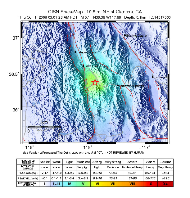
The peak reported intensity from the CIIM reports was MMI V, reported in the town of Independence, approximately 59 km north of the epicenter. Felt reports were distributed similar to the instrumental intensity observed.

The moment tensor solution displays right-lateral strike-slip motion, on a nodal plane striking N33W. This is consistent with the pattern of aftershocks that have occurred so far. Previous events in this area have been observed historically, with 12 events M5.0 or larger that have occurred in this area since 1933. The largest was the M5.8 Ridgecrest Earthquake, which occurred on 9/20/1995. The most recent M5+ event to occur before this sequence was a M5.2 earthquake, which occurred 7 km ESE of Coso Junction on 07/17/2001.
Events in this area have spawned robust aftershock sequences in the past, and earthquake swarms for this area are not uncommon. The distribution of events so far may be seen below in the graph, showing other recent significant sequences. This plot is current as of 14:00 UTC.