
Doug Given, Egill Hauksson, Kate Hutton; Version 1.0 10:00 am PDT 8 August 2012
UPDATE – 11:00 am PDT 10 August 2012
Initial Posting
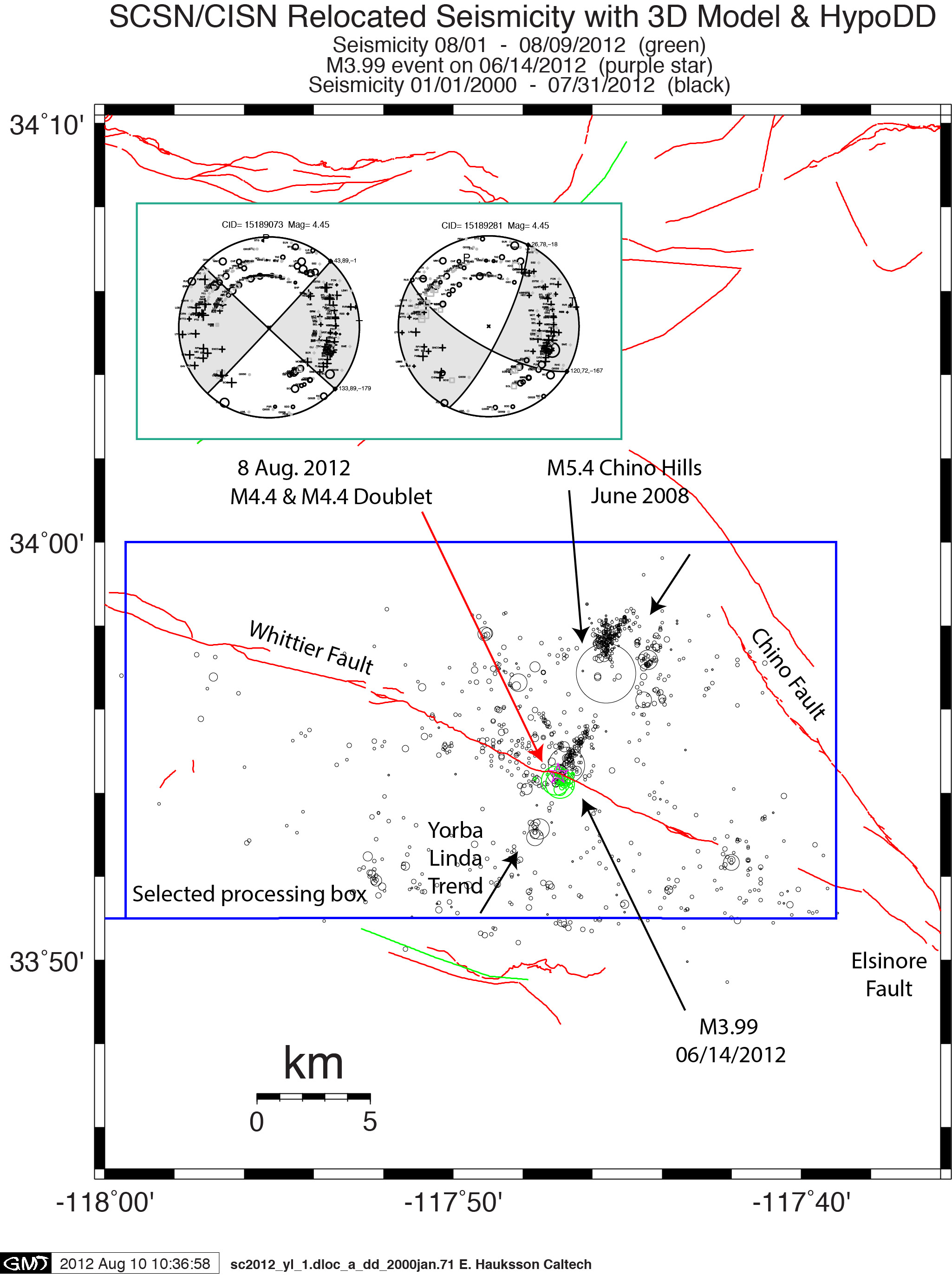
A doublet of M4.5 quakes occurred about 1 km and 10 hours apart near Yorba Linda, CA.
The first was at 11:23pm local time, Tuesday evening, August 7, 2012
The second was at 9:33am, Wednesday morning, August 8, 2012
The occurrence of two quakes close in time has stimulated wide media interest.
Aftershocks – there have been 13 earthquakes in the sequence above magnitude 2.0 recorded as of 10:00 am on Thursday Aug 8.
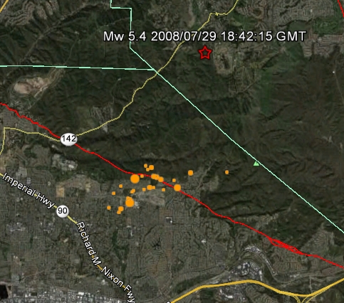
These events are clustered about 5km SW of the M5.4 Chino Hills of July 29, 2008 and are not considered aftershocks of it.
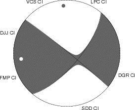
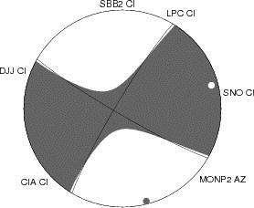
The events are near the Whittier Fault but may not be on that fault. They are located SW of this NE dipping fault, and focal mechanisms are also not exactly aligned with that fault’s strike. The trend in aftershock locations is SW to NE, making that focal plane a possibility.
While most aftershocks are typically smaller than the mainshock, triggering of earthquakes the same size or larger is not uncommon. In fact, in 5% of sequences an earthquake triggers another earthquake the same size or larger. The triggering phenomenon that underlies traditional foreshock-mainshock-aftershock sequences and doublets is the same. In this case of doublets, the aftershock triggered is approximately the same size as the mainshock.
Despite the occurrence of the doublet, the total number of earthquakes that have been triggered in this sequence is near the average expected for California. In the next 24 hours we can expect around 8 earthquakes above magnitude 2 in the region near the doublet. Provided a large aftershock does not occur, aftershock activity will continue to decay in the coming days.
First event
UPDATE OF PREVIOUSLY REPORTED EVENT
Southern California Seismic Network (SCSN) operated by Caltech and USGS
Version 3: This report supersedes any earlier reports of this event.
This event has been reviewed by a seismologist.
| Magnitude | 4.45 Ml (light earthquake) |
| Time | 07 Aug 2012 11:23:34 PM, PDT 08 Aug 2012 06:23:34 UTC< |
| Coordinates | 33 deg. 54.42 min. N, 117 deg. 47.41 min. W 33.9070 N, 117.7902 W |
| Depth | 6.5 miles (10.4 km) |
| Quality | Excellent |
| Location | 1 mi. (2 km) NE of Yorba Linda, CA 28 mi. (45 km) ESE of Los Angeles Civic Center, CA 5 mi. (9 km) WNW of GYPSUM QRY 0 mi. (0 km) ESE of Whittier Fault |
| Event ID | CI 15189073 |
ADDITIONAL EARTHQUAKE PARAMETERS
| Stations used | 155 |
| Phases used | 214 |
| S phases used | 58 |
| RMS misfit | 0.20 seconds |
| Horizontal location error | 0.1 km |
| Vertical location error | 0.5 km |
| Maximum azimuthal gap | 18 degrees |
| Distance to nearest | 9.0 km SSE of 13882 |
| Event magnitudes | Mw=4.0 Ml=4.5 Me=4.3 |
Variance Reduction vs Depth plot
| Hypocentral Location | Event ID 15189073 |
| Origin Time | 2012/08/08 06:23:34 |
| Latitude | 33.9070 |
| Longitude | -117.7902 |
| Depth | (TT) 10.4 km (MT; not authoritative) 5 km |
| Magnitudes | Me 4.35 (not authoritative) Ml 4.45 (authoritative) Mw 3.96 (not authoritative) |
Second event
UPDATE OF PREVIOUSLY REPORTED EVENT
Southern California Seismic Network (SCSN) operated by Caltech and USGS
Version 5: This report supersedes any earlier reports of this event.
This event has been reviewed by a seismologist.
| Magnitude | 4.45 Ml (light earthquake) |
| Time | 08 Aug 2012 09:33:22 AM, PDT 08 Aug 2012 16:33:22 UTC |
| Coordinates | 33 deg. 54.36 min. N, 117 deg. 47.04 min. W 33.9060 N, 117.7840 W |
| Depth | 5.8 miles (9.4 km) |
| Quality | Excellent |
| Location | 2 mi. (3 km) NE of Yorba Linda, CA 28 mi. (45 km) ESE of Los Angeles Civic Center, CA 5 mi. (8 km) WNW of GYPSUM QRY 0 mi. (0 km) ESE of Whittier Fault |
| Event ID | CI 15189281 |
ADDITIONAL EARTHQUAKE PARAMETERS
| Stations used | 151 |
| Phases used | 244 |
| S phases used | 94 |
| RMS misfit | 0.31 seconds |
| Horizontal location error | 0.2 km |
| Vertical location error | 0.4 km |
| Maximum azimuthal gap | 14 degrees |
| Distance to nearest station | 9.0 km SE of 13882 |
| Event magnitudes | Mw=4.1 Ml=4.5 Me=4.4 |
Variance Reduction vs Depth plot
| Hypocentral Location | Event ID 15189281 |
| Origin Time | 2012/08/08 16:33:22 |
| Latitude | 33.8983 |
| Longitude | -117.7922 |
| Depth | (TT) 8.0 km (MT; not authoritative) 5 km |
| Magnitudes | Me 4.38 (not authoritative) Ml 4.45 (authoritative) Mw 4.06 (not authoritative) |