Update Sunday 26 July 2015, 06:00pm PDT.
Ten small aftershocks have occurred so far, the largest being M1.9.
| EVENT ID | MAG | DATE TIME | LAT/LONG | DEPTH (km) | LOCATION |
|---|---|---|---|---|---|
| 37213375 | 1.0 | 2015-07-25 10:59:45 | 34.120 -117.462 | 7.4 | 2km N of Fontana, California |
| 37213455 | 4.2 | 2015-07-25 12:54:06 | 34.092 -117.445 | 5.5 | 1km ESE of Fontana, California |
| 37213463 | 1.2 | 2015-07-25 12:58:25 | 34.093 -117.445 | 5.7 | 1km ESE of Fontana, California |
| 37213471 | 1.6 | 2015-07-25 12:58:43 | 34.088 -117.453 | 3.5 | 1km SSE of Fontana, California |
| 37213535 | 1.4 | 2015-07-25 15:03:26 | 34.092 -117.450 | 5.3 | 1km SE of Fontana, California |
| 37213583 | 1.9 | 2015-07-25 16:44:37 | 34.092 -117.453 | 4.5 | 1km SE of Fontana, California |
| 37213647 | 1.4 | 2015-07-25 17:53:24 | 34.123 -117.455 | 10.6 | 3km N of Fontana, California |
| 37213735 | 1.4 | 2015-07-25 21:34:53 | 34.090 -117.452 | 5.5 | 1km SSE of Fontana, California |
| 37213863 | 0.9 | 2015-07-26 02:10:40 | 34.088 -117.438 | 5.9 | 2km ESE of Fontana, California |
| 37213895 | 0.8 | 2015-07-26 03:11:59 | 34.090 -117.440 | 5.5 | 2km ESE of Fontana, California |
| 37214103 | 0.8 | 2015-07-26 15:45:18 | 34.095 -117.452 | 3.4 | 1km ESE of Fontana, California |
| 37214143 | 1.0 | 2015-07-26 18:04:20 | 34.100 -117.447 | 4.2 | 1km E of Fontana, California |
Update Saturday 25 July 2015, 09:30am PDT.
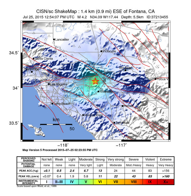
A M4.2 earthquake occurred in Fontana, CA, this morning at 5:54am. The event was shallow, about 5.5km (3.5 mi), which contributed to it being sharply and widely felt.
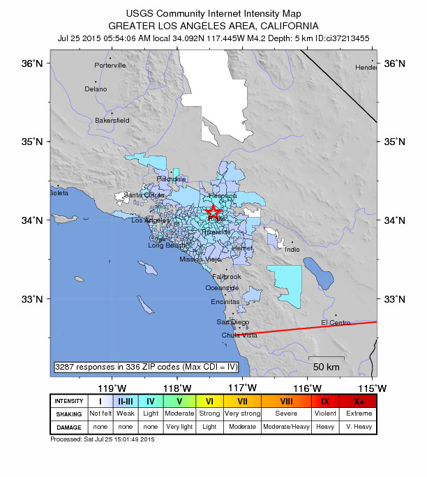
Intensity and DYFI
ShakeMap and DYFI maps show the event was widely felt, with over 3300 DYFI responses so far, and with a maximum aggregated intensity of IV.
Aftershocks
So far a few small aftershocks have occurred (all smaller than M2), and one small event preceded the M4.2 earthquake.
| EVENT ID | MAG | DATE TIME | LAT/LONG | DEPTH (km) | LOCATION |
|---|---|---|---|---|---|
| 37213375 | 1.0 | 2015-07-25 10:59:45 | 34.12 -117.462 | 7.4 | 2km N of Fontana, California |
| 37213455 | 4.2 | 2015-07-25 12:54:06 | 34.092 -117.445 | 5.5 | 1km ESE of Fontana, California |
| 37213463 | 1.2 | 2015-07-25 12:58:25 | 34.093 -117.445 | 5.7 | 1km ESE of Fontana, California |
| 37213471 | 1.6 | 2015-07-25 12:58:43 | 34.088 -117.453 | 3.5 | 1km SSE of Fontana, California |
| 37213535 | 1.4 | 2015-07-25 15:03:26 | 34.092 -117.45 | 5.3 | 1km SE of Fontana, California |
Most likely, the recent mainshock will be the largest in the sequence. However, there is a small chance (approx. 5 to 10%) of an earthquake equal to or larger than this mainshock in the next 7 days. In addition, up to approximately 5 small aftershocks are expected in the same 7-day period and may be felt locally. This probability report is based on the statistics of aftershocks typical for California. This is not an exact prediction, but only a rough guide to expected aftershock activity. This probability report may be revised as more information becomes available.
Geology and Local Faults
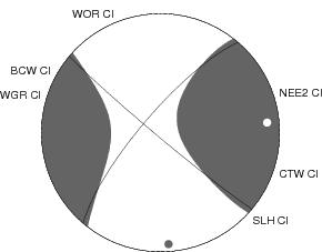
The geology of this area is rather complex, as several larger fault systems all converge in this area. The San Jacinto fault, San Andreas fault, and Sierra Madre fault are all within a few miles of this event. The termination of both the San Jacinto fault zone (the most active fault in Southern California) and the Sierra Madre fault are within two miles. Due to the very complex nature of the geology, the small size of the earthquake that occurred, and the lack of surface rupture, it is difficult to identify the causative fault for this event. The focal mechanism and moment tensor solutions show a strike-slip motion, consistent with previous events in this area.
Local Seismicity in the SCSN Catalogue
Several events have occurred in this area historically, known as the Fontana Seismic Trend, an area that has a trending pattern of smaller events. Since record keeping began in this area in the 1930s, we have had eight other M4.0 or larger events within 10 km of this mainshock:
| EVENT ID | MAG | DATE TIME | LAT/LONG | DEPTH (km) | LOCATION |
|---|---|---|---|---|---|
| 3350653 | 4.1 | 1960-06-28 20:00:47 | 34.127 -117.477 | 1.3 | 4km NNW of Fontana, California |
| 3330737 | 4.5 | 1965-01-01 07:04:17 | 34.13 -117.51 | 3.3 | 6km NW of Fontana, California |
| 3330616 | 4.6 | 1965-04-15 19:08:33 | 34.135 -117.437 | 6.0 | 5km NNE of Fontana, California |
| 503897 | 4.0 | 1983-01-08 06:19:30 | 34.133 -117.453 | 7.8 | 4km N of Fontana, California |
| 129763 | 4.0 | 1987-02-21 22:15:29 | 34.132 -117.447 | 8.5 | 4km NNE of Fontana, California |
| 14116972 | 4.4 | 2005-01-06 13:35:27 | 34.123 -117.445 | 6.7 | 3km NNE of Fontana, California |
| 14355252 | 4.0 | 2008-03-09 08:22:32 | 34.138 -117.465 | 3.7 | 5km N of Fontana, California |
| 11413954 | 4.4 | 2014-01-15 08:35:18 | 34.143 -117.442 | 3.6 | 5km NNE of Fontana, California |
| 37213455 | 4.2 | 2015-07-25 12:54:06 | 34.092 -117.445 | 5.5 | 1km ESE of Fontana, California |
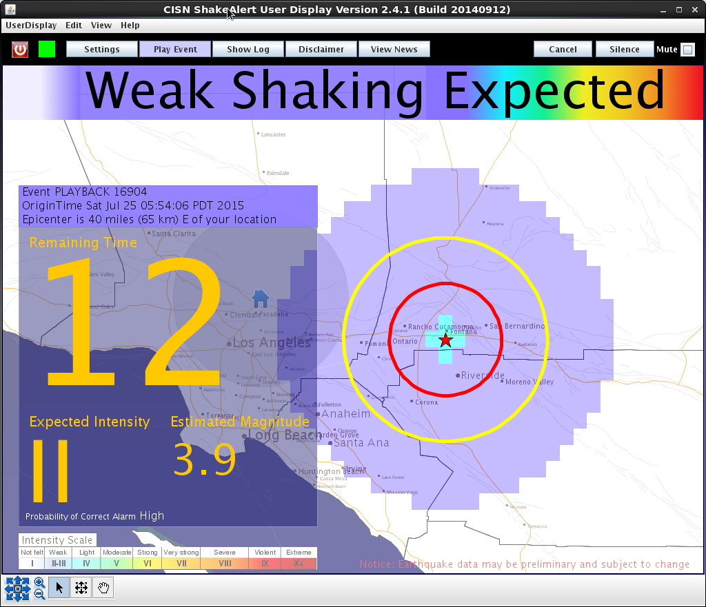
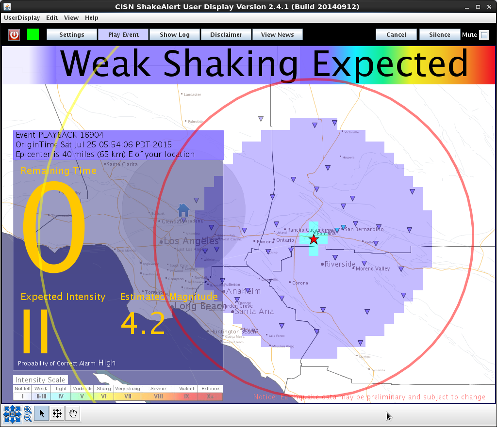
ShakeAlert and Earthquake Early Warning
ShakeAlert is a prototype Earthquake Early Warning (EEW) software that detects ground motion from an event and can send a warning in real-time before the shaking reaches areas at distance. It warns that an earthquake has occurred, and the shaking is on its way. The program worked well for this event, providing an alert for Pasadena with several seconds warning before the shaking began. The program is in beta test mode, and is being tested by collaborators such as first responders, utility companies and emergency services throughout CA.