Last updated September 17th, 2026
Event
- 23 Aug 2026 00:59:55 PDT, (36.067, -117.838), depth 2.8km.
- 10km ENE of Coso Junction, California
Aftershocks
- As of 23 Aug 2026, 12:56PM PDT, there have been 98 aftershocks recorded.
- The largest was M3.5 (smallest M0.1).
- More aftershocks may be expected in the next few days, the largest expected is approximately 1 magnitude unit smaller than the mainshock.
- There is a small chance (about 5%) that a larger quake could occur, with the likelihood decreasing over time.
Possible Foreshocks
- There were 66 events during the 3 days prior to the earthquake (within a 10 km radius).
- The largest was M3.3 (2026/08/21).
Historical Seismicity
- Since our records began in 1932 we’ve had 46 events of M4 or greater within 10km of today’s event.
- The largest historic event was M5.3 on 1996/11/27.
- The most recent historic event was M4.0 on 12 Feb 2021.
Relocated Sequence Model
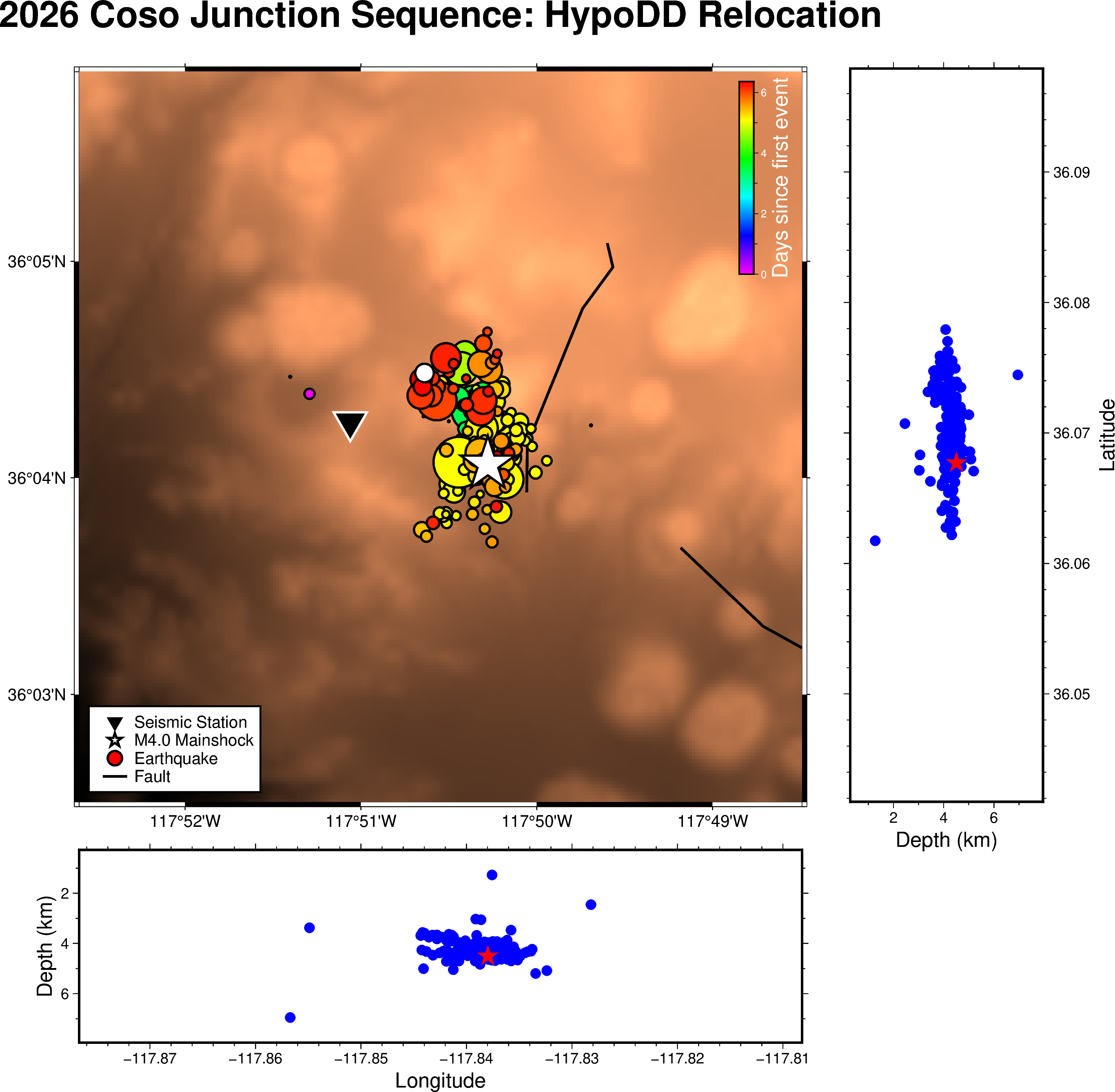
This map, and 3d model above, shows the locations of earthquakes in the 2026 Coso Junction M4/0 Sequence, in Southern California’s High Desert. They were generated using a refined technique called HypoDD (Hypocenter Double-Difference) relocation, which determines earthquake locations by comparing pairs of nearby earthquakes recorded at the same station, rather than relying solely on the absolute travel time of waves through the Earth’s crust. The result is a much more accurate picture of where the earthquakes are actually occurring. Each circle represents one earthquake, with the size scaled to its magnitude and the color indicating when it happened, letting you see how the seismicity evolved over time. The white star marks the largest event in this sequence so far, a M4.0. The two smaller panels along the bottom and right side show depth cross-sections, which help reveal the geometry of the fault system at depth. The map includes events from 5 days before the mainshock and is current as of 2026/08/24, 17:47:14UTC.
Faults
- CFM fault associations: most likely Coso Junction fault (39%). Alternates: Not associated with a CFM modeled fault (4%), Other CFM faults (57%).*
- Nearby faults: Airport Lake fault zone (6.2 km), Unnamed fault east of Rose Valley (8.5 km), unnamed faults south side Owens Lake (11.8 km), Southern Sierra Nevada fault zone, Haiwee Reservoir section (12.1 km), Unnamed fault near Coso Basin (13.0 km) and Little Lake fault zone (13.9 km).**
Additional Information
- Links for: USGS earthquake page, ShakeMap, DYFI, waveforms.
- Visit our special reports page for further information on local notable earthquakes.
- Visit scedc.caltech.edu to access any data recorded by the SCSN.
Below are the waveform data associated with this event, as recorded in our Live Seismograms Feed.
Energy Propgation
Seismic energy propagating across the Southern California Seismic Network following this earthquake. Each circle represents an SCSN station, with warmer colors indicating stronger energy at a four-second period. The close-up highlights how seismic waves can become trapped within the Los Angeles Basin, causing the warmer colors to linger.
*Earthquakes can occur both near or on major known faults, and in places where no clear fault zones are known. Using the statistical method of Evans et al. (in prep. 2019) the location and focal mechanism of this earthquake suggest the above association with modeled faults in the Community Fault Model (CFM) provided by the Southern California Earthquake Center (SCEC) and Harvard University. Note that the CFM fault association may be different from the nearby faults list. Differences may arise due to different fault databases, and because the CFM fault association uses the hypocenter with relation to subsurface 3-dimensional fault orientation models, while the nearby faults list utilizes mapped surface traces as they relate to the epicenter.
CFM Fault: SCEC CFM 7.0 Fault name and closest segment if available; The CFM is maintained by Harvard University, Dept of Earth & Planetary Sciences.
Probability: The probability in percent the earthquake is associated with this fault.
SCSN: Caltech/USGS Southern California Seismic Network
**U.S. Geological Survey and California Geological Survey, 2006, Quaternary fault and fold database for the United States, accessed 2015, from USGS web site: https://earthquake.usgs.gov/hazards/qfaults/
This information is subject to change as more up-to-date data become available.