
Lucy Jones, USGS; Egill Hauksson, Caltech Seismological Laboratory
Also see: www.cisn.org
The M4.9 Yucaipa event occurred on an almost east-west striking vertical fault with thrust motion and a small left-lateral strike-slip component. It is consistent with uplift of topographic features in the area, such as the Crafton Hills. The M4.0 earthquake is within the aftershock area of the M4.9 event.
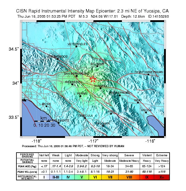
The M4.0 event is located only about 1.0 km to the west of the M4.9 hypocenter and about 1.0 km shallower. It exhibited strike-slip motion, most likely on the left-lateral plane or the plane striking at a high angle to the direction of the San Andreas fault. In detail, the aftershocks form two subparallel clusters that trend almost east-west and are offset by a few hundred meters. This latest M4.0 aftershock is probably associated with the westernmost cluster.The mainshock was widely felt across southern California, particularly in the Inland Empire and the greater Los Angeles basin. The strongest shaking occurred around the Cities of San Bernardino, Riverside, and Lake Arrowhead. It is being followed by a normal pattern of aftershocks, with 35 recorded in the first 2 hours.
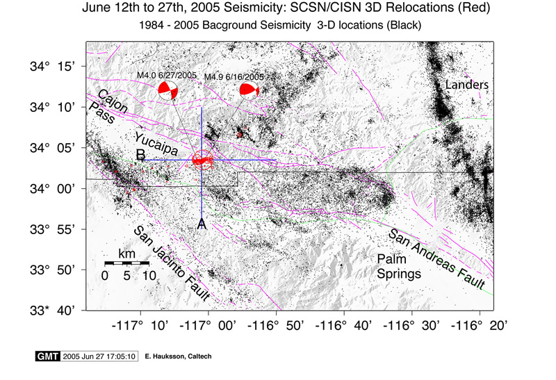
Map of the epicentral area with background seismicity, previous earthquakes/aftershocks, and the current Yucaipa Earthquake and aftershocks.
The Banning segment of the San Andreas fault in southern California is associated with an average rate of background seismicity. This seismicity is scattered throughout the region and does not simply delineate the major strands of the late Quaternary faults. Some of this seismicity is caused by distributed deformation across the region because the southern San Andreas changes directions from northwest to the south of Banning to west-northwest near Cajon Pass.
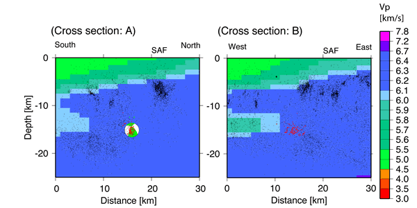
Cross sectional view of hypocenter displaying moment tensor solution and P-wave velocity. The current sequence of seismicity is shown in red, background seismicity is shown in black. Click on image to view full size graphic.
The southern San Andreas fault is a 600 km long branch of the San Andreas system that accommodates horizontal motion between the North America and Pacific Plates. The total length of the San Andreas fault is more than 1200 km (700 miles). The past history of the region includes the 1986 ML5.6 North Palm Springs event that was located approximately 30 km to the south along the same fault system. It was caused by fault movement similar to today’s earthquake.
The image above is the ShakeMap for the M4.9 Yucaipa Earthquake. Strongest shaking may be visible to the west of the epicenter.
-------
-------------------
-------------------------
-----------------------------
##############-------------------
###################----------------
#######################--------------
##########################-----------##
######### ################--------###
########## T ##################----######
########## ###################-########
###############################--########
############################------#######
#########################----------######
####################--------------#####
###############--------------------####
----------------------------------###
---------------------------------##
--------------------------------#
-----------------------------
---------- ------------
------- P ---------
- ---
The image above is the moment tensor solution, showing an east-west striking oblique thrust fault, which is inconsistent with the San Andreas Fault, but is located close by to the San Andreas Fault Zone.