Earthquake Swarm, Including Two MW5.1 Earthquakes in the CA US/Baja CA Mexico Border Region – Located Approximately 20 miles SSE of Calexico, CA
Two MW5.1 Events – 11:12PM February 8, 2008 and 10:29AM February 11, 2008
Report by the California Integrated Seismic Network (Caltech/USGS)
Egill Hauksson, Kate Hutton, Anthony Guarino, and Doug Given
11 Feb. 2008
These earthquakes were felt widely throughout the border region, and felt as far away as Los Angeles to the north, and Col. Vte. Guerrero, Baja CA NTE, to the south. The SCSN portion of CISN does monitor and locate events in northern Baja CA, as the precision is higher due to instrument density.
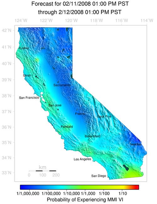
Shown below are the ShakeMaps for the events, displaying the maximum modified mercalli instrumental intensity at or above VI. These events may have caused minor damage in the extreme southernmost portion of California, near El Centro and Brawley.
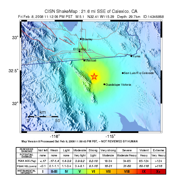
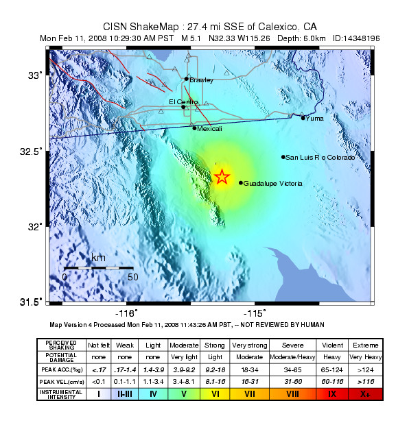
This earthquake swarm started ~20 miles southeast of Calexico, California on 8 February 2008 at 11:12 pm (Pacific Time) with an Mw5.1 (ML5.4) earthquake. A second Mw5.1 earthquake occurred on 11 February 2008 at 10:29 am (Pacific Time) about 4 miles further south. A third Mw5.0 event occurred on 11 February at 8:32 pm. During the first 3.5 days, 35 earthquakes of ML3.0+ and numerous smaller quakes have occurred, forming this earthquake swarm. Because these events are located outside the seismic network, the location accuracy is only ~5 km, and depths are poorly constrained. However, most events are shallow, or at focal depths of 3 miles or less.
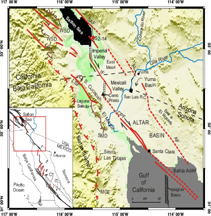
These earthquakes are occurring near the Cerro Prieto Geothermal field. The geothermal field is located on the west side of a step over between the Cerro Prieto fault and the Imperial fault. This most recent earthquake swarm and the active part of the geothermal field are located close to the north end of the Cerro Prieto fault. In the larger picture, the Cerro Prieto fault connects to the San Jacinto fault system to the northwest.
The fault map of the general region that is shown in Figure A, also illustrates the relationship between this seismic activity and the major faults in the region. The Imperial fault had major damaging earthquakes in 1940 M7 and 1979 M6.5. The southern end of the San Jacinto fault zone last had a damaging earthquake of M6.6 in 1987 along the Superstition Hills fault.
If seismicity starts occurring on these faults, to the north of the current activity, there is cause for concern in California. Such activity could be associated with the Imperial fault to the north, or one of the San Jacinto fault strands to the northwest, such as the Superstition Mountain fault. However, such migration of activity has not been reported in past earthquake swarms in Imperial Valley or south of the border.
The earthquake statistics for this sequence are summarized in Figure B. The first 48 hours of the sequence showed some decay in activity as expected for mainshock aftershock sequences. During the last 24 hours, the activity has shown almost no decrease, which is often the case for earthquake swarms in this region. Also, the ratio of large to small earthquakes has increased, which suggests changes in the driving stress. If this behavior persists, we could expect more earthquakes in the M5 range in the next few weeks, which could possibly be spaced further apart in time. A less likely scenario would be a major earthquake along the Cerro Prieto fault rupturing to the south.
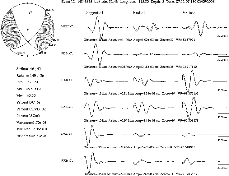
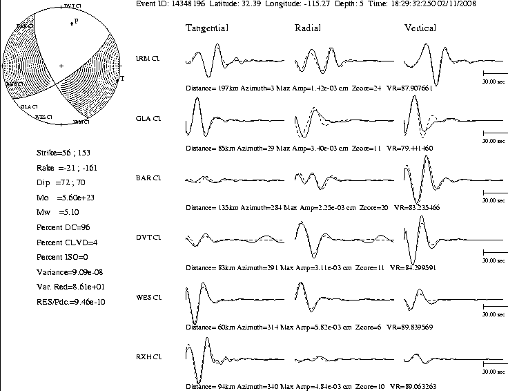
The three Mw5.1 earthquakes had similar right-lateral strike-slip mechanisms with a small normal component (about 30%), suggesting tectonic movement consistent with activity on the Cerro Prieto fault, as well as some extension in the area of the step-over (Figure C). Earthquake swarms of M4 to M5 are common in the Cerro Prieto region. The most recent moderate-sized earthquake was a Mw5.4 that occurred on 24 May 2006, and cause surface fractures. Two other moderate-sized events occurred on 1 June (MW4.8) and 10 Sept. (Mw4.8) in 1999. Similarly, these types of earthquake swarms have occurred in the past in other parts of Imperial Valley and Mexicali Valley, especially in the 1930s and 1970s, and have not been immediate precursors to large earthquakes.
References
- Francisco Suárez-Vidal, Luis Munguía-Orozco, Mario González-Escobar, Javier González-García, and Ewa Glowacka Surface Rupture of the Morelia Fault Near the Cerro Prieto Geothermal Field, Mexicali, Baja California, Mexico, during the Mw 5.4 Earthquake of 24 May 2006 Seismological Research Letters, May/June 2007; 78: 394 – 399.
- Martín Pacheco, Arturo Martín-Barajas, Wilfred Elders, Juan Manuel Espinosa-Cardeña, Javier Helenes, and Alberto Segura Stratigraphy and structure of the Altar basin of NW Sonora: Implications for the history of the Colorado River delta and the Salton trough Revista Mexicana de Ciencias Geológicas, 2006, v. 23, núm, 1, 2006, p. 1-22
To fill out a felt report, click here